South Africa Market
The Nine Provinces of South Africa
South Africa has nine provinces, each with its own legislature, premier and executive council - and distinctive landscape, population, economy and climate. They are:
- The Eastern Cape
- The Free State
- Gauteng
- KwaZulu-Natal
- Limpopo
- Mpumalanga
- The Northern Cape
- North West
- The Western Cape
Before 1994, South Africa had four provinces: the Transvaal and Orange Free State, previously Boer republics, and Natal and the Cape, once British colonies. Scattered about were also the grand apartheid "homelands", spurious states to which black South Africans were forced to have citizenship.
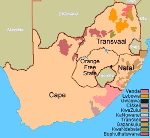
A map of South Africa before 1994, showing the original four provinces of the Cape, Orange Free State, Natal and Transvaal, as well as the grand apartheid "homelands" (Image: South African History Online)
Under South Africa's new democratic constitution the four provinces were broken up into the current nine, and the "homelands" blinked out of existence. The Cape became the Western Cape, Northern Cape, Eastern Cape and the western half of North West, while the Transvaal became Limpopo, Mpumalanga, Gauteng and the eastern half of North West.
Natal was renamed KwaZulu-Natal, incorporating the "homeland" of KwaZulu, and the Orange Free State became simply the Free State.
Land area
There are vast differences in the size of the provinces, from tiny and crowded Gauteng to the vast, arid and empty Northern Cape. Mpumalanga is the second-smallest province after Gauteng, with the rest all taking between 8% and 14% of South Africa's total land area:
There are vast differences in the size of the provinces, from tiny and crowded Gauteng to the vast, arid and empty Northern Cape. Mpumalanga is the second-smallest province after Gauteng, with the rest all taking between 8% and 14% of South Africa's total land area:
- Eastern Cape - 168 966 square kilometres
- Free State - 129 825 square kilometres
- Gauteng - 16 548 square kilometres
- KwaZulu-Natal - 94 361 square kilometres
- Limpopo - 125 755 square kilometres
- Mpumalanga - 76 495 square kilometres
- Northern Cape - 372 889 square kilometres
- North West - 106 512 square kilometres
- Western Cape - 129 462 square kilometres
Land area by province
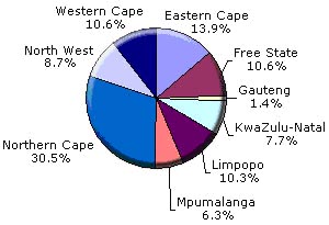
(Data source: Statistics South Africa)
Population
The number of people living in the provinces also varies considerably. KwaZulu-Natal, the third-smallest province, has the largest population, and tiny Gauteng the second-largest. By contrast the Northern Cape, which takes up nearly a third of South Africa's land area, has by far the smallest population.
The number of people living in the provinces also varies considerably. KwaZulu-Natal, the third-smallest province, has the largest population, and tiny Gauteng the second-largest. By contrast the Northern Cape, which takes up nearly a third of South Africa's land area, has by far the smallest population.
The mid-2006 population estimates for all nine provinces are:
- Eastern Cape - 6.9-million
- Free State - 2.9-million
- Gauteng - 9.5-million
- KwaZulu-Natal - 9.9-million
- Limpopo - 5.6-million
- Mpumalanga - 3.5-million
- Northern Cape - 1-million
- North West - 3.4-million
- Western Cape - 4.7-million
Population by province
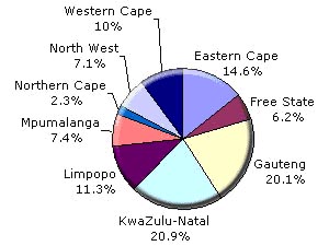
(Data source: Statistics South Africa)
This variation translates into huge differences in population density. Gauteng has an average of 576 people per square kilometre, while the Northern Cape is extremely roomy, with only three people for each square kilometre.
Population density by province
(Number of people per square kilometre)
(Number of people per square kilometre)
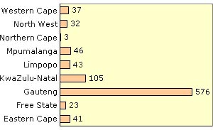
(Data source: Statistics South Africa)
Languages
Although English is the lingua franca of South Africa, there's considerable variation in home languages between the provinces. IsiXhosa, for instance, is spoken by more than 80% of people in the Eastern Cape, while almost 80% of those in KwaZulu-Natal speak isiZulu. IsiZulu is also the most common home language in Gauteng, but at a much smaller percentage. In Cape Town and its surrounds, Afrikaans comes into its own.
Although English is the lingua franca of South Africa, there's considerable variation in home languages between the provinces. IsiXhosa, for instance, is spoken by more than 80% of people in the Eastern Cape, while almost 80% of those in KwaZulu-Natal speak isiZulu. IsiZulu is also the most common home language in Gauteng, but at a much smaller percentage. In Cape Town and its surrounds, Afrikaans comes into its own.
Predominant languages by province (2001 figures, rounded off) are:
- Eastern Cape - isiXhosa (83%), Afrikaans (9%)
- Free State - Sesotho (64%), Afrikaans (12%)
- Gauteng - isiZulu (21%), Afrikaans (14%), Sesotho (13%), English (12%)
- KwaZulu-Natal - isiZulu (81%), English (13%)
- Limpopo - Sepedi (52%), Xitsonga (22%), Tshivenda (16%)
- Mpumalanga - siSwati (31%), isiZulu (26%), isiNdebele (12%)
- Northern Cape - Afrikaans (68%), Setswana (21%)
- North West - Setswana (65%), Afrikaans (7%)
- Western Cape - Afrikaans (55%), English (19%), isiXhosa (23%)
Government
Each province has its own provincial government, with legislative power vested in a provincial legislature and executive power vested in a provincial premier and exercised together with the other members of a provincial executive council.
Each province has its own provincial government, with legislative power vested in a provincial legislature and executive power vested in a provincial premier and exercised together with the other members of a provincial executive council.
The legislature has between 30 and 80 members elected for a five-year term based on the province抯 portion of the national voters' roll. The legislature is empowered to pass legislation within its functional areas
The premier is elected by the legislature and, as with the President at national level, is limited to two five-year terms in office. The premier appoints the other members of the executive council (MECs), which functions as a cabinet at provincial level. The members of the executive council are accountable individually and collectively to the legislature.
Economy
Population density correlates with the provinces' slice of South Africa's economy, with Gauteng having the biggest. The tiny province punches way above its weight, contributing 33.3% to the national gross domestic product and a phenomenal 10% to the GDP of Africa as a whole. Next is KwaZulu-Natal with 16.7%, followed by the Western Cape with 14.4%.
Population density correlates with the provinces' slice of South Africa's economy, with Gauteng having the biggest. The tiny province punches way above its weight, contributing 33.3% to the national gross domestic product and a phenomenal 10% to the GDP of Africa as a whole. Next is KwaZulu-Natal with 16.7%, followed by the Western Cape with 14.4%.
Provincial contribution to national GDP
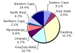
(Data source: Statistics South Africa)